Historic Flooding - March 1, 1902

A Glimpse at the Past
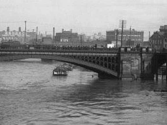
The most severe flood of the tidal Schuylkill River on record crested on March 1, 1902. It was an extreme example of a freshet, a type of flooding caused by a heavy rainstorm that melts snow upriver.
A typical high tide mark, or crest, on the Schuylkill is 6 to 6.5 feet. Flooding occurs when storms, strong winds, and/or other weather conditions cause the crest to rise to least 11 feet. At 14.8 feet, this record-breaking crest flooded the railroad tracks and buildings along the river.
The photos here show flood waters in and around the B&O Train Station that was located at 24th and Chestnut Streets.
Record floods on the tidal Schuylkill:
- 10/4/1869 17 ft (this crest data is considered unreliable)
- 3/1/1902 14.8 ft
- 8/24/1933 14.7 ft
- 7/9/1935 14.1 ft
- 5/24/1942 12.4 ft
- 8/9/1942 13.1 ft
- 6/23/1972 14.7 ft
- 6/2/1946 14.6 ft
- 11/25/1950 14.3 ft
- 11/22/1952 12.4 ft
- 8/19/1955 14.3 ft
- 9/13/1971 13.3 ft
- 1/28/1976 12.1 ft
- 1/26/1978 12.3 ft
- 1/25/1979 13.0 ft
- 7/7/1984 12.3 ft
- 12/5/1993 12.4 ft
- 1/19/1996 13.4 ft
- 9/17/1999 14.1 ft
- 10/9/2005 12.1 ft
- 6/28/2006 12.5 ft
- 10/1/2010 13.1 ft
- 8/28/2011 13.6 ft
- 9/8/2011 12.5 ft
- 5/1/2014 13.9 ft
Sources:
- https://www.phillyhistory.org/blog/index.php/2011/10/schuykill-river-floods-march-1902/
- https://www.phillyhistory.org/PhotoArchive/Detail.aspx?assetId=5688
- https://www.phillyhistory.org/PhotoArchive/Detail.aspx?assetId=5690
- https://www.phillyhistory.org/PhotoArchive/Detail.aspx?assetId=5686
- https://www.phillyhistory.org/PhotoArchive/Detail.aspx?assetId=5687
- https://www.weather.gov/media/marfc/FloodClimo/SEPA/Philadelphia.pdf
- Report of the Water Supply Commission of PA
- https://tidesandcurrents.noaa.gov/noaatidepredictions.html?id=8545120&legacy=1


